Datasets
The North Carolina sample data set
For the GRASS GIS book we have prepared a new, modern sample GIS data set. This data set is a comprehensive collection of raster, vector and imagery data covering parts of North Carolina (NC), USA. The data were prepared from public data sources provided by the North Carolina state and local government agencies and Global Land Cover Facility (GLCF).
Data are provided at three hierarchical levels
- entire NC with raster data at 500m resolution (boundary in geographic coordinates: 37N-33N,75W-85W);
- Southwest Wake county with raster data at resolutions 30m-10m (boundary coordinates 35:48:34.6N-35:41:15.0N, 78:46:28.6W-78:36:29.9W), and
- a small watershed in rural area with data resolutions of 1m-3m.
The data set includes section of the NC capital city Raleigh and its surroundings. The coordinate system of the ready-to-use GRASS data set is NC State Plane (Lambert Conformal Conic projection), metric units and NAD83 geodetic datum. Additional data are provided in geographic coordinates and NC State Plane, english units (feet) in various external formats.
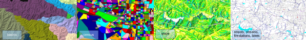
Vector data include administrative boundaries, census data, zipcodes, firestations, hospitals, roads and railroads, public schools and colleges, bus routes, points of interest, precipitation, hydrography maps, geodetic points, soils and geological maps.
Raster data include elevation (NED 3arc-sec, SRTM-V1 30m, lidar derived DEMs at 1m and 6m), slope, aspect, watershed basins, geology, and landuse. The resolution of raster maps is 500m, 30m, 10m, and 1m.
Imagery data include 1m resolution orthophoto, several LANDSAT-TM5/7 scenes and a MODIS daily Land Surface Temperature (LST) time series.
Also multiple-return LiDAR data are included. The examples throughout the book are based on this data set. Furthermore, new derivative maps are generated and explained.
Dataset overview
Take a tour through the data set with many screenshots:
H. Mitasova, M. Neteler, 2007: OSGeo sample dataset for research, development and education. Proc. Free and Open Source Software for Geospatial (FOSS4G) conference, 24-27 Sep 2007, Victoria, Canada [PDF]